UK meteorology

I'm going to be having a neck X-ray this afternoon - if I've fractured a vertebra or displaced something and have to stay in hospital, I'd suggest you chaps check the forecast (I recommend BBC ones as the presenters are either full Met Office meteorologists or broadcast meteorologists with close links to the Met Office), and the Met Office warnings page:

http://www.metoffice.gov.uk/public/weather/warnings/
Thanks Chris. Hope all will go well for you today.
 
I don't know, very festive at Crimbo are hospitals and you get to avoid all the relies, at least they can only get to you two at a time.

Judging by the previous info about Leeds ( where I've never been ) I'm guessing that the hospitals in that area are waay livelier and more entertaining than the Calvinistic sobrietry to which I'm more accustomed in our neck of the woods Count.

JohnnyO. o/
 
Very confused models regarding the Christmas period. Friday's named storm appears to be heading for the gap between Scotland and Iceland; this would result in the worst gusts being localised in western and northwestern Scotland and the Hebrides - possibly 80-90 mph. Uncertainty regarding the second system is high considering it's this weekend - at present, there is achance that the worst of the winds may be over the far south of Scotland, Northern Ireland and northern England/Midlands, however, that possbility greatly reduced the strength of the system, with maximum gusts around 50-60 mph. Other models suggest a powerful storm clipping the far north and northwest, but not too bad in the Central Belt.
 
Very confused models regarding the Christmas period. Friday's named storm appears to be heading for the gap between Scotland and Iceland; this would result in the worst gusts being localised in western and northwestern Scotland and the Hebrides - possibly 80-90 mph. Uncertainty regarding the second system is high considering it's this weekend - at present, there is achance that the worst of the winds may be over the far south of Scotland, Northern Ireland and northern England/Midlands, however, that possbility greatly reduced the strength of the system, with maximum gusts around 50-60 mph. Other models suggest a powerful storm clipping the far north and northwest, but not too bad in the Central Belt.
It's good to have you back in the weather seat Chris...;)
 
Tomorrow's storm appears to be weakening (or rather, it appears that it isn't strengthening to the degree that was expected. It seems that the worst gusts will be for the Northern and Western Isles (80 mph or so) with the mainland having 'only' around 50-60 mph gusts.

Met Office latest warning for the Christmas Day storm:

Yellow wind warning for Christmas day and early boxing day

Issued at: 11:50 on Thu 22 Dec 2016

Valid from: 03:00 on Sun 25 Dec 2016

Valid to: 09:00 on Mon 26 Dec 2016

A further spell of very strong winds is expected on Christmas Day (Sunday). Gusts of 50 to 60 mph are likely to occur quite widely, locally up to 70 mph. There is a lower likelihood of gusts exceeding 80 mph across the far north of the mainland and the Northern Isles. There is potential for disruption to holiday travel plans (for example restrictions on bridges and delays to ferry services). Other impacts, primarily across northern Scotland, may include disruption to power supplies and large waves affecting coastal areas, while heavy rain in the West Highlands combined with snow melt may lead to rising river levels. This warning has been updated to extend the validity time into Boxing Day (Monday).

A deepening depression will move northeastwards across the Atlantic, passing northern Scotland during the Christmas period and bringing a broad swathe of gales and severe gales to much of Scotland. There remains a fair degree of uncertainty in the exact track and intensity of the depression, which reduces confidence concerning the threat of particularly strong winds across the far north. Turning much colder later Christmas Day (Sunday) and into Boxing Day (Monday) morning, with blustery showers increasingly turning to snow. Some slight accumulations of around 2-4 cm are possible above 200 metres.
 
Update on today's storm from Netweather:

http://www.netweather.tv/index.cgi?action=news;storyid=7857;sess=
Quoted from the link:

The run up to Christmas sees Barbara our second named storm of the autumn/winter season. Amber weather alerts have already been issued warning of damaging storm force winds of up to 90mph over North and North West Scotland. There'll also be gusts of 60 to 80mph across much of the North later today...a strong South or South West wind will give gusts of 40 to 60mph in squalls across the North and West of England later his afternoon and into the evening, but it's over North and West Scotland, where the power of ‘Barbara' will be most felt. Here gusts of 70 to 90mph will be strong enough to bring down trees, topple over high sided vehicles and cause structural damage so beware!

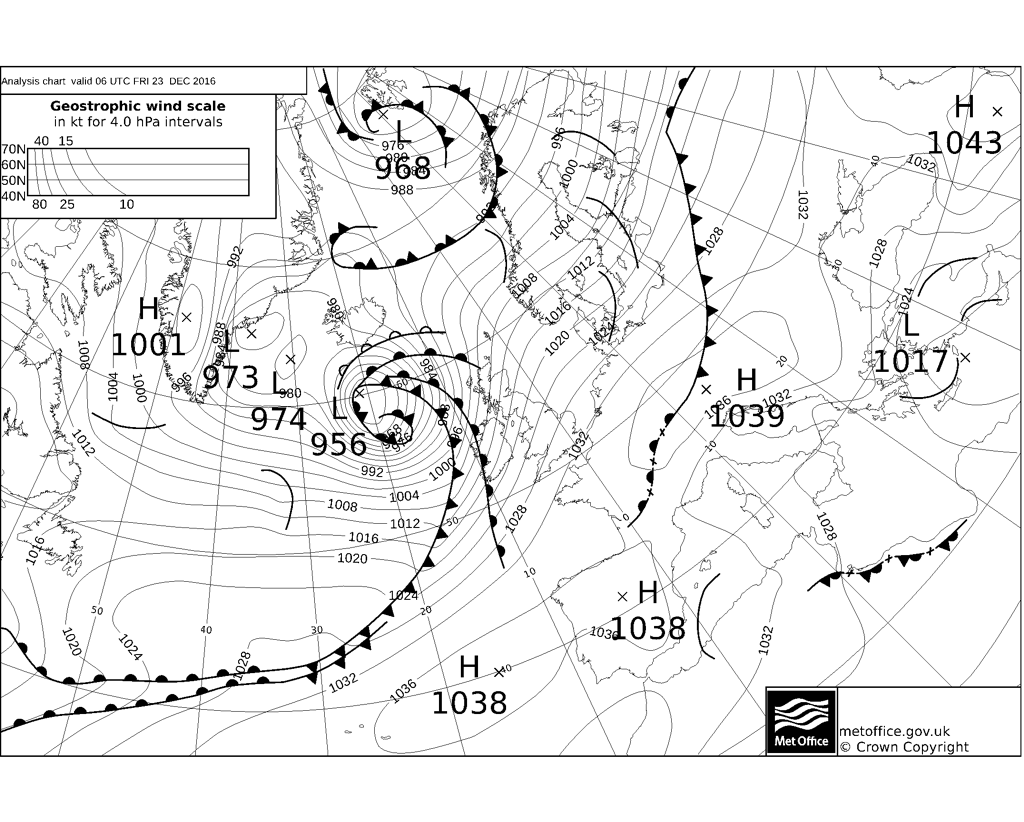
Here's the latest FAX chart from the Met Office (I intend to cover these in a furture 'lesson'). The storm, can quite clearly be seen to the west of Scotland, with the isobars close together on its southern flank:
20161223.0623.PPVA89.png
 
And, indeedly, just by looking out our rear ( north ) facing window I can barely see the crags which extend some miles parallel to our home Chris. In fact, it's rather like being surrounded by fast blowing clouds at the moment where I am. If clouds are filled with driving sleet/rain. On a more personal note, hope the neck isn't troubling you as much m8.

JohnnyO. o/
Neck is fine, thanks Johnny. Sounds as though the system is nearing you - take care of yourself over the next few hours!
 
Back
Top Bottom