
You are using an out of date browser. It may not display this or other websites correctly.
You should upgrade or use an alternative browser.
You should upgrade or use an alternative browser.
UK meteorology
- Thread starter chrisbell
- Start Date
- Messages
- 17,611
- Location
- Sunny Cornwall
Well, the straight down incessant driving rain is slightly warmer ..
JohnnyO. o/
There is always an up side!
")
- Messages
- 2,549
Yup means I don't have to try and water the garden with a small watering can, silver linings and all that.
OP
- Messages
- 6,299
- Location
- Norfolk, England
- Thread Starter
- #596
No hosepipe?Yup means I don't have to try and water the garden with a small watering can, silver linings and all that.
- Messages
- 2,549
No outdoor tap that works and no easily accessible indoor one that would work with a hose.. The tap for the garden comes from next doors outside loo and has a stopcock in one of their outbuildings which turns and another stopcock which isolates it and the outside loo that doesn't turn. I haven't traced it all yet so I haven't tried taking a bar/lever to it.No hosepipe?
OP
- Messages
- 6,299
- Location
- Norfolk, England
- Thread Starter
- #598
Modelling suggests warmth for all next week; high teens to low twenties in northern Scotland, with low-to-mid twenties for southern Scotland, northern England, Wales and the northern Midlands. Further south, higher temperatures and greater humidity are likely, but there is a chance of a smalll, thundery low pressure area developing which could divide the surface high pressure in two, resulting in the most settled weather in the north, with only perhaps the Western Isles seeing Atlantic-driven weather. Areas west and south-west of London seem likely to get the highest temperatures - high twenties or low thirties Celcius, but, should this small, cut-off Low materialise, and one of the divided high pressure centres establish itself in the North Sea, the flow would tend to draw in a cooling easterly breeze for my area and other eastern coastal districts.
- Messages
- 2,549
OP
- Messages
- 6,299
- Location
- Norfolk, England
Glorious here today so I'm assuming all our rain is falling on @JohnnyO again.
I can see the loch, which means it's about to rain ... if I couldn't see it it would be raining.
JohnnyO. o/
OP
- Messages
- 6,299
- Location
- Norfolk, England
- Thread Starter
- #602
Actually, there's no rain anywhere near you on radar, Johnny.I can see the loch, which means it's about to rain ... if I couldn't see it it would be raining.
JohnnyO. o/
- Messages
- 2,549
STEALTH RAIN!!
Whatever will they think of next!
Whatever will they think of next!
Actually, there's no rain anywhere near you on radar, Johnny.
YAY @ Chris ! High time you arranged some encouragement for an olde m8. Actually got up to around 19C by 16.00 hrs.
JohnnyO. o/
STEALTH RAIN!!
Whatever will they think of next!
Loving that thought Count !
JohnnyO. o/
OP
- Messages
- 6,299
- Location
- Norfolk, England
- Thread Starter
- #606
Empty radar images are pretty rare when you're checking the entire UK, so I noticed it.YAY @ Chris ! High time you arranged some encouragement for an olde m8. Actually got up to around 19C by 16.00 hrs.
JohnnyO. o/
OP
- Messages
- 6,299
- Location
- Norfolk, England
- Thread Starter
- #607
Something of a change in model emphasis this morning. To quote a retired Met Office man who is a Netweather member (my explanatory notes in bold):
Difficult to know what to make of the last couple of gfs runs so a perusal of the GEFS (ensemble version of the American GFS model) and in particular the ecm is definitely required but until then I'm inclined to treat with extreme caution. On the face of it seems to be producing some amplification (in other words, a more meridional set-up as opposed to a zonal one) with not good results.
It follows the script until Monday with the breakaway upper trough splitting the HP (high pressure) in mid Atlantic but then it initiates the amplification with the Central European high pushing north into Scandinavia and, importantly, quite strong ridging over NE North America. This creates an upper low between Greenland and Iceland with the associated trough dominating mid Atlantic. Whilst at the same time the high pressure over the UK is moving east and the Iberian low is making a foray north.
The twin surges of the ridges continues forcing the aforementioned upper low to track south east to be just west of N. Ireland by 00 Friday (midnight Friday morning) and consequently surface low pressure to the west and north west is tending to dominate the UK with fronts traversing the country during Friday.
OP
- Messages
- 6,299
- Location
- Norfolk, England
- Thread Starter
- #608
Further to the above, here is the latest Netweather synoptic guidance blog:
http://www.netweather.tv/index.cgi?action=news;storyid=8286;sess=
Note discussion of the divided jet across the Atlantic. This later allows what is called a cut off low (so called as it has high pressure to the north of it cutting it off from the main vortex, unlike a standard low ) to form over Iberia and drift to the north as the northern arm of the jet ridges over us while the southern arm continues to head south-east.
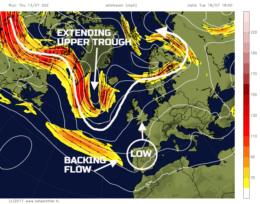
Last edited: