UK meteorology

It seems that, after a brief mild spell on Wednesday/Thursday, next weekend will be chilly (though nothing like as snowy as some have had this weekend), before a change in the jetstream takes effect, bringing much more typical Atlantic zonal conditions, with average temperatures and rain (more so in the north and west) up to and possibly through Christmas. Personally, I suspect that will remain the pattern through the rest of winter, as, once a vortex lobe positions itself over Greenland, it often stays there into spring, however, some of those who study the global patterns and oscillations suspect that it won't last long. Whether they're correct remains to be seen, but I'd be surprised if anywhere bar the Highlands see a White Christmas; cloudy, mild and damp is much more likely.
 
What's going to cause this shift to milder conditions? It's a change in the wave number of the polar jet (which I dewcribed way back several months ago in a 'lesson' post) and its effect on the Pacific North American (PNA) pattern, shifting it from a positive phase to a negative one. Here's an excellent post from Netweather explaining what that means:

Looks like we have a pattern change coming this weekend and I'll describe what I think may happen based on the model output.

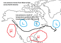
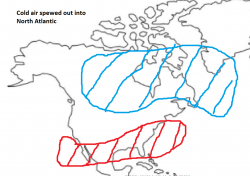
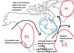
However first, lets have some context… why is the pattern changing? Well a big part of the change can be attributed to the Pacific North American pattern (PNA). What is this?, well here are some basic diagrams to show its effects. The top two panels show the synoptic pattern and the bottom two show the temperature anomalies.

The synoptic pattern over the USA when the PNA is strongly positive is one where we have high pressure over the western USA (like recently). That is the main thing and usually there is lower pressure over NE Canada or the NE USA.

Positive PNA - SLP Negative PNA - SLP

Positive PNA - temperature Negative PNA - temperature
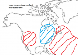

So its probably little surprise that this pattern has contributed to increased wildfire activity in this region. The downstream effects (North Atlantic) are that the Azores high is more likely to ridge North which is what we have been seeing.

Due to the cold air from Canada being deposited over the SE USA, low pressure systems over around the coastal areas where cold continental air meets the warmer temperatures of the North Atlantic. Low pressure systems typically move NE off the Eastern seaboard and some of these get trapped in the far NE Canada or USA. Thus encouraging ridging of the Azores high.

However we are seeing a transition to a more negative PNA which is shown on the right hand panel. Often the high Pressure over California is not as strong allowing the jet to dive further west in the USA instead. The SE USA is often under warm air from the Gulf of Mexico. Areas of low pressure zip across Canada and carry cold Canadian air into the North Atlantic.

We therefore see a region of rapid deepening of low pressure due to the cold Canadian air meeting the warmer Atlantic. Low pressure moves past Greenland and warm air from the SW Atlantic hits us instead.

Now there are some variations over the PNA but a somewhat similar kind of pattern change explains why there is a stronger chance of mild westerlies coming into play over the UK.

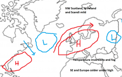
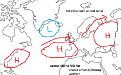
Though how this Atlantic energy is split will determine how mild the UK gets. So here is the basic scenario on Sunday. Now we have mild air racing across the North Atlantic but a slightly displaced Azores high close by. From here three scenarios could develop within the following couple of days.

Sunday
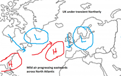

Scenario 1: 15% Scenario 2: 35% Scenario 3: 50%
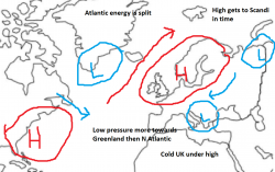


The first is a Scandinavian high which has a fair chance of happening but it probably wouldn't occur that quickly due to the amount of energy in the North Atlantic jet. Also there is the issue of that low over Scandi blocking its Eastward progress.

The second is an anticyclonic outlook. Here the Azores high ridges across but a lot of energy goes over the top. Many parts of the UK would still be cold because of the short days. Slack winds and weak solar heating means temperatures can't recover during the day. In these situations T850 ensembles can be misleading because it can be cold at the surface despite warmer temperatures higher up (known as a temperature inversion). Warm air will likely affect NW areas though and a slight modification could see either the whole of the UK cold or mild.

The final scenario is one where the Atlantic wins out over the following few days. This could lead to either mild SW winds if there is a pressure build to our east as well or a more alternating mild/cool pattern with westerlies.

Finally a Scandi high could develop later from the other two Scenarios. The middle panel wouldn't be that bad if some blocking could develop from the high pressure. Overall these are just a bunch of scenarios that I think will develop from the model output. Lets see what the 12z's bring.
 
After my aunt's funeral and getting frozen cold yesterday, I'm feeling rough today, so I'll just quickly mention that the models suggest a warm-up at the start of next week after a chilly few days with snow over high ground in the north. At present, the models are struggling to work out how long this milder, Atlantic-influenced weather will be. It's likely to lead to mild, even warm conditions and mainly dry weather in the south-east (low teens possible), with wetter, windier conditions in the north-west.
 
After my aunt's funeral and getting frozen cold yesterday, I'm feeling rough today, so I'll just quickly mention that the models suggest a warm-up at the start of next week after a chilly few days with snow over high ground in the north. At present, the models are struggling to work out how long this milder, Atlantic-influenced weather will be. It's likely to lead to mild, even warm conditions and mainly dry weather in the south-east (low teens possible), with wetter, windier conditions in the north-west.
I hope you are feeling better or at least less rough soon Chris. Take care.
 
Something of a change in the models last night and this morning. While the period through until Christmas hasn't changed since I posted yesterday, the development from then through to the first week or so of January seems much less likely to turn cold. Instead, a switch to wet and windy Atlantic-driven zonality, with low pressures moving across the UK in rapid succession giving all of us some very wet and windy conditions seems the preferred evolution, though cold conditions are still a possibility. Dare I say that January has a winter of 2013/14 feel to it (flooding in the West Country and high winds)?
 
Further to the above, here's an interesting post from a knowledgeable Netweather member, though bear in mind that he has a bias towards cold weather at this time of year:
The progression we're seeing the models explore (somewhat inefficiently perhaps, but getting there) is one in which the Canadian vortex has a window in which to venture towards Europe via Greenland, but then comes under attack from upstream changes with the Pacific ridge heading back poleward and initiating a buckling of the jet pattern that should encourage the vortex lobe to come apart a bit, with some getting pulled back into N. America while the rest either heads into Europe (as either a large organised trough as 00z ECM tries for or a smaller one following trough disruption as per the 00z) or digs south in the middle-N. Atlantic.

The former resembles our predominant pattern of Nov-Dec so far, but tweaked to allow for more the way of Scandinavian height rises as a follow-up to the trough dropping in. The latter is a different path, more like we had to go through in Nov 2009 - and laden with the risk of some mild, wet weather while we wait for ridging to make its way sufficiently north from Europe to turn the tables in favour of cold. This manner of evolution has a habit of drying out just as it turns cold enough for snow, though.

GFS 06z is very much the latter scenario.


This setup is also easy to tilt unfavourably with a bit of climatological bias and/or over-deepening of troughs, which I believe explains some of the less than inspiring ensemble behaviour of late.


It is for reasons like this that the festive period has a valid stormy weather risk, but given the (at least) equally plausible alternative scenario of a trough setting up over Europe again, I'm not inclined to expect a windy washout route at this stage.


GFS still managed to get quite close in the end on a hemispheric scale - a nice interpretation of the Pacific-Scandi relationship, shame about that dartboard low!
 
Back
Top Bottom